Sept. 12, 2003 Stow-on-the-Wold
Wow! Just two days in the Cotswolds and we’re already planning a return trip.
We arrived by train in Moreton-in-Marsh and immediately saw one of the oldest curfew towers (a bell was rung to warn residents to cover their fires) in the country.

We had to drag the rolly-pollies to the bus stop, and very soon the bus dropped us off in the square at Stow-on-the-Wold, and then we were welcomed at the Unicorn Hotel. It was authentically creaky, and appeared to have been built in Tudor times (or soon after) — typical honey-colored stone with irregular little hallways and ancient beams. Our room was very comfortable. We wandered around down a short country track and watched horses and dogs, then had a really good dinner in the Unicorn restaurant. We got all sorted for our stay in Oxford at the TIC, then bought a walking guide and went to bed.
Yesterday we got a not very early start, after a really great breakfast, and walked down through the fields and through gates and over stiles to Bourton-on-the-Water. Lunch was at a really posh restaurant at a hotel by the footpath in Lower Slaughter. Full of good food, we soldiered on to Bourton after a short break for churchspotting and postcarding.
Bourton was harder to get to from Slaughter than it looked — we went a bit wrong and took an alternative footpath through a new suburb built to look old. Once in the main square of Bourton, we wandered along the River Windrush, window shopped, and explored the back streets. I’ve been

photographing pub signs, and David’s been taking pictures of water and ducks, so in Bourton there was plenty of each. We wandered and explored and then managed to find the Stow bus for “home.” Time for a nap, even!
Dinner was at Hamiltons, a newish brasserie that was quite stylish and a very nice change from all the “ye olde tea shoppe” sort of restaurants. I had two yummy things off the starter menu –“ratte” potatoes and gazpacho soup. For the soup they had frozen the puree after straining the soup – it kept the soup cold and added extra punch as it melted. David had poached chicken, wild mushrooms, and linguine. So we’re clearly not starving, though we’ve tended to avoid smoky pubs, which in future might be our only choice in places like Fort William.
It’s a food and walking adventure — yesterday’s walk in the light rain showed that we’re capable of finding our way using maps, waymarks, and a developing eye for spotting the way well trodden across otherwise featureless meadows.
Afterwords: February 13, 2004
Looking back, we really should have rented a car and stayed in the Cotswolds for at least a week, but we were just barely venturing out into Britain, and I didn’t want to put that on David’s shoulders so early in the trip. So we’re already thinking about a return trip, and I’ve found at least one self-guided walking tour to check for price and availability. Heh.
When we decided to walk from Stow to Bourton, we weren’t carrying an official Landrangers map, we just had a little walking map booklet. So we weren’t encouraged to wander off the route and follow a different footpath coming out somewhere else along our way. However, for our first outing, it was probably best that we not wander, since as it was we took a wrong turning somewhere just beyond Lower Slaughter and had to muddle our way into Bourton.
Here’s the little map we followed. Looks simple enough:

Yes, it was raining that day.
Following the directions, we followed the track past Quarwood Cottage to a gate leading to a field, failing to note the direction the footpath arrow was pointing. So we walked straight into the field, and the path disappeared, and left us with nothing much to look at except a field that dropped vaguely away on the front and left to a treeline. We kept walking toward the trees, because we knew from the directions that eventually we’d be walking downhill alongside water.
When we decided to walk from Stow to Bourton, we weren’t carrying an official Landrangers map, we just had a little walking map booklet. So we weren’t encouraged to wander off the route and follow a different footpath coming out somewhere else along our way. However, for our first outing, it was probably best that we not wander, since as it was we took a wrong turning somewhere just beyond Lower Slaughter and had to muddle our way into Bourton.
We were entranced by the distant prospect of a village on the hill opposite…

… but eventually came back to our senses and started looking along the fenceline as we came up to it for the tell-tale gate and arrow symbol. Sure enough, we had moved too far to the right, and had to backtrack uphill a little. Only then did we realize that the trail symbol with the arrow actually meant something, as in “continue in the direction I’m pointing, you simps.” Back at the first gate, I thought it just meant “go through this gate.”
Okay, so we figure that out and soon came to rely on the arrow’s direction. We walked on downhill through some woodlands and across a road or two, always staying on the footpath and avoiding private property.
We noticed a number of horses in the fields, and then came past a very large, new barn that was in use – someone inside was driving a practice coach and four horses.
That was distracting enough (it’s a very large facility, and through the open doors we could see the horses being driven around inside) but then we realized we had a field to cross with some horses in it.

But at least the trail was easy to spot! There it goes diagonally toward the gate in the corner, passing close by the horses.
David wanted to go around.
I did not. I wanted to see the horses.
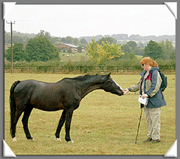
“My little pony! Can I keep ‘im?”
“No.”
After My Little Pony’s mom came up and inquired as to my intentions, we moved carefully along so as not to spook them or the other horses in the meadow and carried on toward the mill mentioned in the trail directions. (She was very nice about it, she just walked up and loomed over me, so I backed off).
At one point, we had a nice chat with a young woman who was cleaning out a drain in her driveway, in the company of her friendly Labrador retriever. We passed the time of day, and she warned us that they’d moved the trail slightly about 50 yards farther on, in order to keep walkers from messing up a neighbor lady’s front walkway. We took the hint and followed the detour signs — it was silly, it just took us off the lane, into a field where we couldn’t be seen as easily from the lady’s house, and then back onto the lane after passing her house. We then realized that the trail had indeed been moved in order to avoid messing up her view with a pack of chattering, untidy walkers and their horrible beards and backpacks. Harrrumph.
After this point, it became a question of counting fields and spotting the next gate. We entered one field that had recently held a lot of cows and thought ourselves lucky that we had missed them, as we hopped and skipped over and around the cow pats. Then in the next field, we found the cows. And the entire herd was massed around the exit gate. Delicious! What to do? But fortunately, the farmer was just coming into the field with a few bales of hay in the front scoop of his loader, and he waved to us in a friendly manner and drove up to the far end of the field with the hay, with the herd of cows obediently (and rather impatiently) following along beyond. Nice man! We waved back enthusiastically and hopped and skipped along to the next lane.
It became quite a mental game – “was that 3 fields, or 4? Did that last one count?” because we weren’t sure about the scale of the map, and thought we might have taken a wrong turn and missed the village of Lower Slaughter. But occasionally we’d stop to take pictures, because after all we were on vacation and although we were currently in the middle of some farmer’s field in Britain, eventually we’d find our way.
Finally, at last, we found the elusive cricket ground mentioned in the directions, and spotted the church spire and found ourselves in Lower Slaughter. There was indeed a mill there, too, with the normal offerings of post cards and ice cream.
Time for lunch, but what to do? Pub? No restaurant in sight, but what about that rather posh hotel?

We ended up at the Washbourne Court hotel for lunch, and they were quite willing to talk walkers’ money so long as we took off our boots.
Fortunately, there were plenty of other patrons there with their boots off, so we settled into comfortable chairs and splurged on a pretty expensive lunch for what it was – high-end ham sandwiches, if I recall- but the setting was very nice. The flowers in their gardens and their window boxes were still so pretty, and it’s right on the river (Eye, I think, not the Windrush) which was little more than a tiny canal. It was lovely and we could have stayed longer, but we had to get a move on. If you’d like to stay there, they thoughtfully provide directions for where to land your helicopter.
After a quick look at the church of St Mary’s, which had a lych gate,

we blundered on as described, following the path along the watercourse and encountering a smartly-dressed couple walking their beagle. They were older, but they were exquisitely neat, and looked as if they could have stepped from the pages of Country Life. I’d never seen such beautiful outdoor attire (and shoes!) so perfect for walking a beagle in the English countryside. We were too shy to ask for their permission to photograph them.
About then was when we went wrong on the route – we went along the path they’d just come from when we should have continued a little farther before turning, but we ended up in Bourton just the same. We shopped for a bit at an outdoor store (that happened to be outdoors at the time), wandered farther along the footpath that follows the Windrush, and then stopped at a pub with a nice garden for a bite and a bevvy:

It was a great day, so “well done, us.”